")
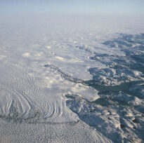
ESSIC Assistant Research Scientist Zhuosen Wang is a co-author on a new paper, “Evaluation of satellite remote sensing albedo retrievals over the ablation area of the southwestern Greenland ice sheet”.
Typically, MODerate resolution Imaging Spectroradiometer (MODIS) albedo products are validated over the uniform, snow-covered areas of the Greenland ice sheet using the single ‘point-to-pixel’ method. This study expands on this method by applying a “multiple point-to-pixel” method and examination of spatial autocorrelation. Using 232 ground-based samples, the researchers found little difference in accuracy among narrow and broad-based albedos.
These results suggest that the MODIS albedo product performs well in a very heterogeneous, low-albedo area of the ice sheet ablation zone. Furthermore, the researchers found that single ‘point-to-pixel’ methods alone are insufficient in characterizing and validating the variation of surface albedo displayed in the lower ablation area.
Wang is the chief architect of the Collection V006 MODIS BRDF/Albedo/NBAR algorithm and science PI of the NASA Black Marble nighttime light product. Wang co-leads the CEOS Land Product Validation (LPV) Subgroup Surface Radiation/Albedo Product Validation focus area. Wang’s areas of interest include monitoring energy services in human settlements using Suomi-NPP VIIRS Day/Night Band, modeling and evaluation of land surface anisotropic characteristics and albedo, and estimating canopy structure using optical remote sensing and Lidar.
To access the paper, click here: “Evaluation of satellite remote sensing albedo retrievals over the ablation area of the southwestern Greenland ice sheet”.