")
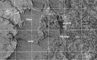
ESSIC / CICS Senior Faculty Specialist Ron Vogel presented a wintertime boating safety webinar on the use of satellite radar measurements to detect ice in coastal waters. The class benefited state, federal, and academic field crews and monitoring personnel who conduct wintertime surveys of coastal conditions. Also benefiting were National Weather Service forecasters for improving marine forecasts.
Satellite data from spaceborne synthetic aperture radar (SAR) instruments can provide high spatial resolution information on maritime surface features such as wind, waves, ice, and oil slicks. Vogel provided specific instruction for interpreting satellite imagery so that field personnel and forecasters can make better safety decisions.
In his research, Vogel applies earth-observation satellite data to environmental decision-making. He currently develops decision-support tools for water quality, fisheries and climate change in coastal areas. Other interests include ecological modeling with satellite data and vegetation and land surface monitoring by satellite. He has expertise in both visible and infrared satellite remote sensing.


