")
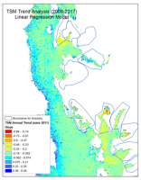
Ron Vogel, ESSIC / CICS Senior Faculty Specialist, recently presented results of an innovative application of satellite data to the Environmental Protection Agency’s Chesapeake Bay Program, the agency responsible for coordinating the pollution cleanup of Chesapeake Bay.
Working alongside partners from NOAA’s Fisheries Service, the group applied satellite estimates of improving water clarity to changes in overall oyster biomass. Since oysters efficiently filter the water where they live, improved water clarity is but one potentially positive outcome of the federal, state, and non-profit sponsored oyster restoration projects occurring within the Chesapeake Bay watershed.
The water quality results produced through the research help both the public and policy makers to reconcile the multi-million dollar investment in environmentally restoring Chesapeake Bay.
In his research, Vogel applies earth-observation satellite data to environmental decision-making. He currently develops decision-support tools for water quality, fisheries and climate change in coastal areas. Other interests include ecological modeling with satellite data and vegetation and land surface monitoring by satellite. He has expertise in both visible and infrared satellite remote sensing.


