")
Ron Vogel, ESSIC / CISESS Senior Faculty Specialist, gave a lecture at the Maryland Association of Environmental and Outdoor Education Annual Conference, a conference for K-12 environmental science teachers to explore using oceanographic satellite data in K-12 classrooms. This area has traditionally seen satellite data as too complex for teaching about the environment.
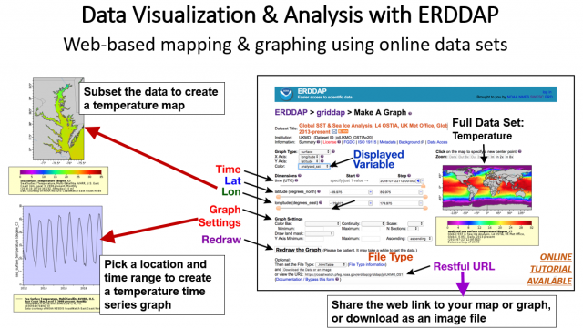
Vogel presented on applications of satellite data to environmental issues and then showed satellite data tools to the teachers that could be used in classrooms, including web-based satellite data viewers and the ERDDAP online mapping and graphing data analysis tool. The group discussed how satellite data could be used in the science classroom, with many teachers offering ideas such as using satellite data to understand risk and decision-making (e.g. climate), comparing different locations experiencing different environmental conditions, teaching students how to make maps and temporal trend graphs, and creating video games using satellite data because that’s how students are learning today.
There was sufficient interest among the teachers for further exploration, so Vogel will be hosting a webinar in the near future to teach the teachers how to use the tools and get their feedback on creating specific science lessons with satellite data. NOAA’s Chesapeake Bay Office environmental literacy team was instrumental in coordinating Ron’s involvement in the conference and will be involved in the webinar and with creating the science lessons.
In his research, Vogel applies earth-observation satellite data to environmental decision-making. He currently develops decision-support tools for water quality, fisheries and climate change in coastal areas. Other interests include ecological modeling with satellite data and vegetation and land surface monitoring by satellite. He has expertise in both visible and infrared satellite remote sensing.


