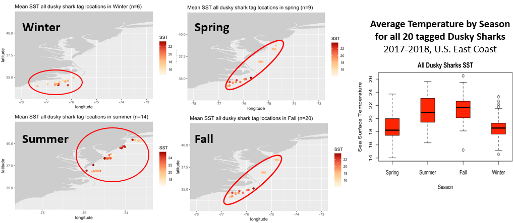
Ron Vogel, ESSIC/CISESS Senior Faculty Specialist, and Melanie Abecassis, ESSIC/CISESS Assistant Research Scientist, designed and taught a specially tailored NOAA CoastWatch satellite training class for the fisheries research community. The fishery researchers use tagged fish to understand population dynamics and ecosystem change; however, use of satellite data in this research is still somewhat limited. In order to fill this gap, the class featured satellite parameters that are underutilized in this research but have been identified by the fisheries community as an area for research growth, such as satellite-derived seascapes, geostrophic currents, sea surface height anomaly and salinity.
In addition, Vogel and Abecassis expanded existing analytical and teaching tools in order to accommodate the needs of this research community. Group projects allowed participants to use new skills derived from the classroom to support their research. This was the first NOAA CoastWatch class in which the tutorials, in-class activities and other materials were fully tailored to meet the needs of a specific community, which demonstrates CoastWatch’s expanding remote sensing education service and positions CoastWatch at the cutting edge of scientific research.
With an expanded set of parameters and specialized tools, the research aims to better understand the environmental drivers of changes in fish populations. Benefits of the research outcomes are improved risk assessments and decision support in fisheries management through ecosystem approaches (known as Ecosystem Based Fisheries Management), a particular emphasis by NOAA Fisheries in the context of changing ecosystems due to climate change.
27 participants from academia, state & federal government, and ocean-observing & fish-telemetry research networks attended at least one of the 4 weekly sessions. Below are some of their comments collected in a post-course survey:
“Thanks to the course organizers for taking the time and making the effort…I think it will go a long way towards making these data products more accessible to researchers who don’t necessarily have a dedicated background in remote sensing/satellite telemetry.”
“This class was extremely helpful and comprehensive. I will certainly be using info from this class with my tracking data in the future.”
“This course really helped me out with several of my dissertation chapters!”
In his research, Vogel applies earth-observation satellite data to environmental decision-making. He currently develops decision-support tools for water quality, fisheries and climate change in coastal areas. Other interests include ecological modeling with satellite data and vegetation and land surface monitoring by satellite. He has expertise in both visible and infrared satellite remote sensing.
Abecassis is part of the NOAA CoastWatch program. Abecassis is a Marine Ecologist with a PhD from the University of Toulouse, France. Melanie’s research interests include animal habitat modeling and understanding endangered species bycatch. In her former role with CoastWatch, she managed the OceanWatch website and data platforms (https://oceanwatch.pifsc.noaa.gov/) to make ocean satellite data available to a wide range of users and now focuses on developing and conducting training workshops to teach users how to use satellite data in their research projects.


