")
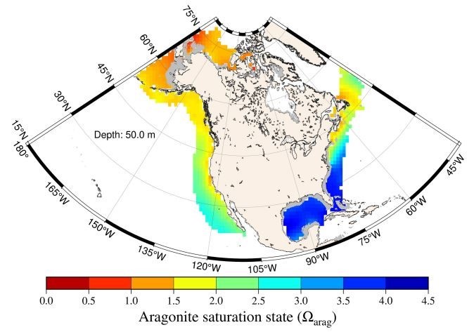
Evaluating Rainfall and Graupel Retrieval Performance of the NASA TROPICS Pathfinder Through the NOAA MiRS System
ESSIC scientists involved with the NASA TROPICS CubeSat mission recently built an algorithm for hydrometers retrieval. In a paper in Remote Sensing of Environment, John
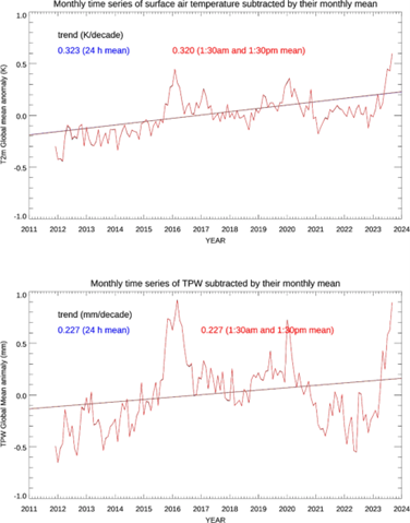
![Figure 3. Monthly TPW anomaly time series shown in red for ERA5 and blue for MiRS SNPP, 2012-2021. The straight lines are the linear regression fits. [a] is for global, [b] for Tropics, and [c] for mid-latitude regions, respectively.](https://essic.umd.edu/wp-content/uploads/2024/11/grassotti-zhou.png)

![Figure. Example of a mapped data product: seasonal means of dissolved inorganic carbon [CT(RFR-LME)] in the Northern Hemisphere (a) winter (December-January-February), (b) spring (March-April-May), (c) summer (June-July-August), and (d) fall (September-October-November) over the period 1998–2022 within each U.S. LME.](https://essic.umd.edu/wp-content/uploads/2024/08/jiang-1.jpg)