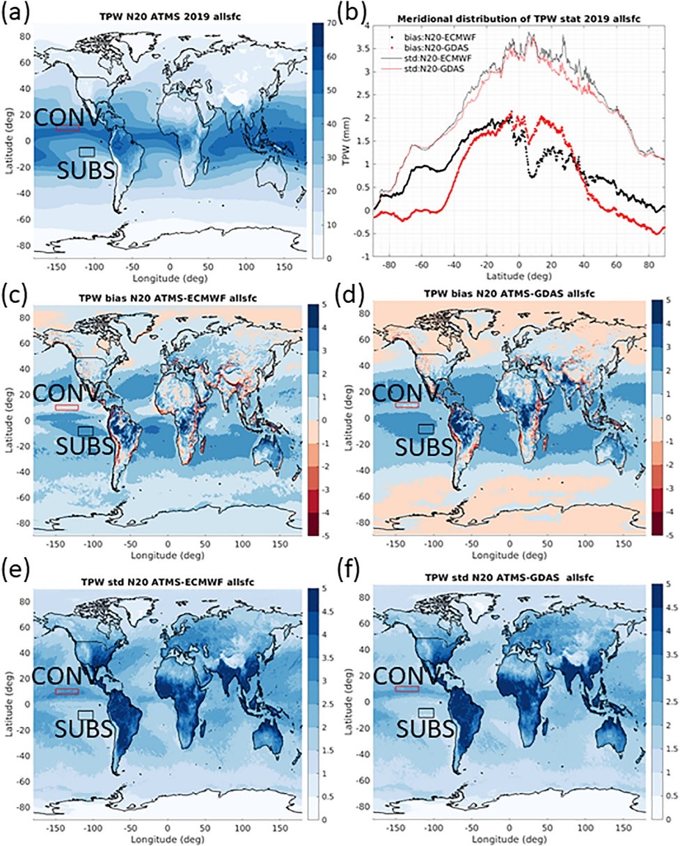
Home » mirs

Tag: mirs

Figure 1. (a) Horizontal distribution of MiRS NOAA-20 ATMS TPW for all of 2019, (b) meridional distribution of statistics for MiRS NOAA-20 ATMS TPW versus ECMWF (black) and GDAS (red) (dots are bias (mm) and lines are standard deviation (mm)): number of pixels are more than 1.2 million for each latitude between 80°S and 80°N. Beyond this area the number of pixels decreases significantly. Global distribution of bias (mm) of (c) MiRS NOAA-20 ATMS TPW – ECMWF TPW, (d) MiRS NOAA-20 ATMS TPW – GDAS TPW, standard deviation (mm) of MiRS NOAA-20 ATMS TPW versus (e) ECMWF TPW and (f) GDAS TPW. All results are for combined ascending and descending orbits in 2019. The red box (120°W ∼ 150°W & 8°N ∼ 12°N) in each plot indicates an area typically characterized by strong convection (CONV area) and the black box (100°W ∼ 120°W & 5°S ∼ 12°S) indicates an area typically dominated by subsidence (SUBS area).

In-Depth Evaluation of MiRS Total Precipitable Water From NOAA-20 ATMS

The MiRS Science Team, composed of ESSIC/CISESS scientists Yong-Keun Lee and Christopher Grassotti, as well as NOAA STAR scientist Mark Liu, published a paper this week titled “In‐Depth Evaluation of MiRS Total Precipitable Water From NOAA‐20 ATMS Using Multiple Reference Data Sets” in Earth and Space Science. Lee was the first author of the study.

Read More »
Figure 1. MiRS NOAA-20/ATMS retrieved TPW (descending and ascending orbits) on 24 October 2021 over the eastern Pacific and West Coast region. The atmospheric river is clearly seen. Locations of the four vertical cross-sections shown in Figure 2 are indicated by the dashed lines.

NOAA’s MiRs Captures Category 5 Rainfall Event in California

On October 24, a powerful Category 5 (the maximum possible) atmospheric river (AR) occurred over the northern and central parts of California. The storm system featured record breaking precipitation, leading to flooding and mudslides in some locations, along with dangerous winds exceeding 70 miles per hour at higher elevations. San Francisco recorded its fourth highest single-day rainfall amount of over 4 inches. Satellite passive microwave measurements are one of the observational tools that allow depiction of these extreme events, since microwaves are less affected by clouds and precipitation.

Read More »