Home » huan meng

Tag: huan meng

Daily examples for the refined AMSR-2

Improving Soil Moisture Retrieval with AMSR2

ESSIC/CISESS scientist Jifu Yin is the first author on a two-part series published in IEEE Transactions on Geoscience and Remote Sensing on refining the Advanced Microwave Scanning Radiometer 2 (AMSR2) soil moisture retrieval algorithm. The paper’s co-authors include ESSIC scientists Jicheng Liu, Huan Meng and Ralph Ferraro.

Read More »
Two animations made by Yongzhen Fan’s team using their snowfall rate product showing the evolution of the two winter storms.

Virtual Workshop on “Precipitation Estimation from LEO Satellites: Retrieval and Applications”

Last week, NOAA NESDIS held a two-day virtual workshop on “Precipitation Estimation from LEO Satellites: Retrieval and Applications”. The workshop was organized by CISESS Consortium Scientist Kuolin Hsu at University of California, Irvine through a task funded by NESDIS’ Joint Polar Satellite System (JPSS) Program Office. The primary goal of the workshop was to determine future satellite observation requirements for global precipitation. The workshop had nearly 100 participants for each of the four sessions that spanned two days.

Read More »
Figure: (Top panel) Rain-Rate predicted by eTRaP and observed by MRMS. (Bottom panel) Scatter plot and estimation metrics for Tropical Storm Fiona between September 18, 2022 12 UTC to September 19, 2022 12 UTC.

NPreciSe Evaluation of eTRaP during Tropical Storm Fiona

Tropical Storm Fiona struck Puerto Rico on September 17-18, 2022 causing catastrophic floods and leaving most of the island with a major power outage. Fiona is the first Atlantic storm this season to cause a major disaster. NPreciSe (NOAA Satellite Precipitation Validation System) led by the CISESS science team (Malar Arulraj, Veljko Petkovic, Ralph Ferraro, and Huan Meng), evaluated the performance of the Ensemble Tropical Rainfall Potential (eTRaP) forecasts during this event, using a recently added Multi-Radar/Multi-Sensor (MRMS) observation product over Caribbean Islands.

Read More »
Figures 1 and 2: Snowfall rate from Pacific Northwest snowstorm on April 13, 2022, (left) NOAA-20 SFR, (right) NOHRSC

Microwave Snowfall Rate Product Captures Late Season Pacific Northwest Snowfall

The STAR scientist team of Huan Meng, Yongzhen Fan, Jun Dong, and Yalei You examined the performance of snowfall estimates from the passive microwave snowfall rate (SFR) product for the late season snowstorm that hit Washington and Oregon on April 13. The storm set the local record for most snow accumulation this late in the season, causing power outages and road closures across Portland, Oregon.

Read More »
Snow falling around some pine trees

Snowfall Rate Product Captures First Nor’easter in 2022

The first nor’easter of 2022 swept through the Mid-Atlantic and the Northeast on January 2-4, 2022, resulting in a heavy snow accumulation of up to 14 inches in Virginia and southern Maryland and stranding hundreds of drivers on Interstate 95 in Virginia. The NOAA NESDIS Snowfall Rate (SFR) product captured the evolution of the snowstorm with retrievals from the Advanced Technology Microwave Sounder (ATMS) sensor aboard the S-NPP and NOAA-20 satellite missions, and the AMSU-A/MHS sensors aboard NOAA-19, Metop-B, and Metop-C.

Read More »
Figure: S-NPP SFR during the first accumulating snow of the 2021-2022 winter season in the central Appalachian counties.

Snowfall Rate Page for Local NWS Office

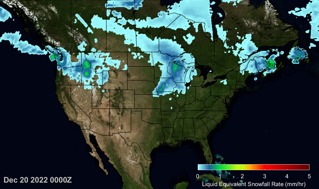
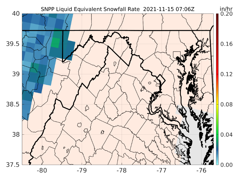
The ESSIC/CISESS snowfall rate (SFR) team, Huan Meng, Jun Dong, and Yongzhen Fan, set up a webpage for the NWS Sterling, VA Weather Forecast Office (Office Call Sign: LWX) at the request of Luis Rosa, a senior forecaster from the office. The page is set for the LWX county warning area (CWA). Currently, the page has the operational SFR images from five satellites but will be expanded to include the experimental SFR from four other satellites. The SFR product is produced at CISESS from direct broadcast data retrieved from the University of Wisconsin. The product latency ranges from 12-25 min depending on the satellite.

Read More »
Figure 1. Global and regional validation of the logistic regression (blue), deep neural network (orange), random forest(green) and XGboost (red) snowfall detection (SD) model for S-NPP.

Fan and Meng Develop New Machine Learning Snowfall Detection Algorithm

ESSIC/CISESS scientists Huan Meng and Yongzhen Fan have recently developed a new machine learning snowfall detection (SD) algorithm, based on eXtreme Gradient Boosting (XGB). The algorithm was developed for the Advanced Technology Microwave Sounder (ATMS) onboard NPP and NOAA-20 as well as the MHS/AMSU-A onboard Metop-A, Metop-B, Metop-C and NOAA-19.

Read More »