Home » Cryosphere

Tag: Cryosphere

ESSIC Featured in Fifth National Climate Assessment

ESSIC Assistant Research Scientist Justin Pflug is an author attributed on the Fifth National Climate Assessment, the U.S. Government’s preeminent report on climate change impacts, risks, and responses. The congressionally-mandated effort provides the scientific foundation to support informed decision-making across the United States. Pflug is attributed on two chapters, “Water” and “Compound Events”.

Read More »
The image on the left is from satellite imagery in a CA Sierra Nevada watershed. The image on the right is the same image with snow (blue pixels) identified using the approach discussed below. CREDIT: Justin Pflug

Estimating Forest Snow Resources Using Commercial Satellite Observations

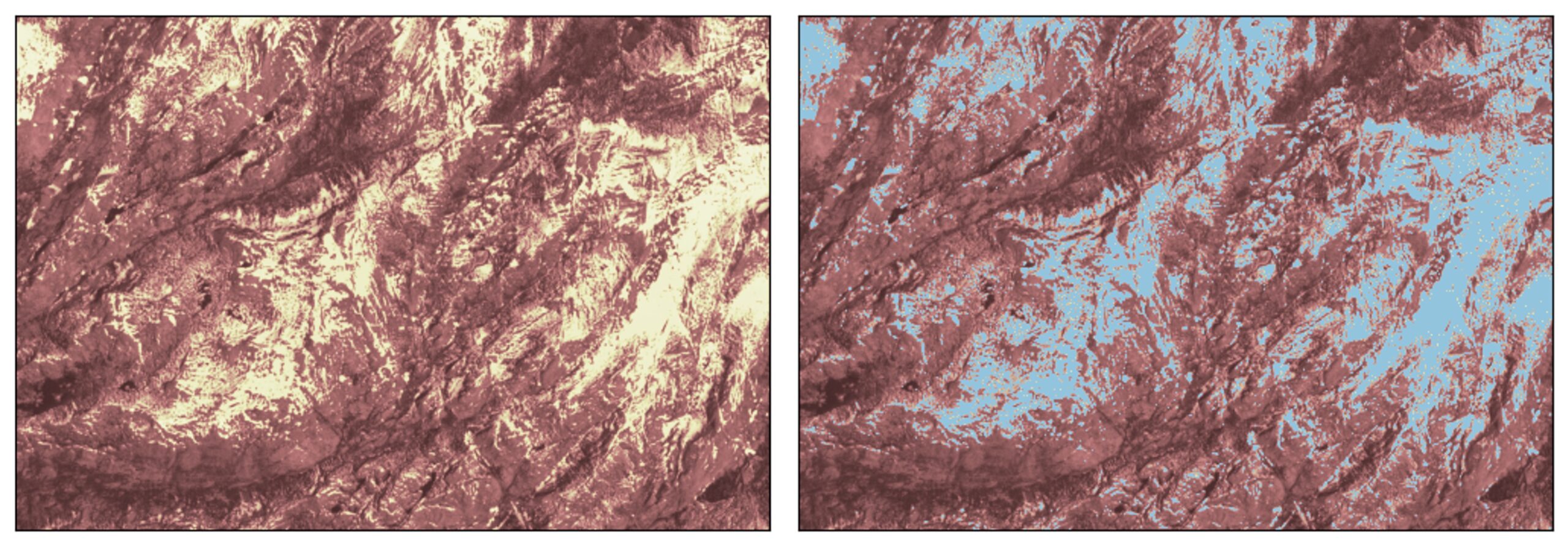
1.2 billion people around the world rely on seasonal snow for their water supply. However, no snow-focused satellite currently exists. The satellites that do attempt to look at the spatial coverage and temperature of snow often struggle to retrieve information about snow in forested regions, which accounts for nearly half of Earth’s snow cover. The forest canopy blocks a lot of satellite remote sensing retrievals, forcing scientists to rely on models. However, processes that control how snow accumulates and melts are pretty different in forested and exposed locations. For example, warmer forests like in the US Pacific Northwest have larger amounts of snow intercepted by the forest canopy and winter snowmelt. This typically makes snow last longer in clearings than in the forest. The opposite is true in colder climates, where snow tends to last longer in the forest.

Read More »
The maps above show simulated storm tracks and wind speeds of nine Arctic cyclones. The left image represents simulated storm tracks as they hit the Arctic in the past decade. The right image shows how the cyclones are projected to respond to climate change by the end of the century. Credits: NASA Earth Observatory/Joshua Stevens, using data from Parker, C.L. et al.

Arctic Cyclones to Intensify as Climate Warms

In findings published on Nov. 9, a team of NASA scientists led by ESSIC research scientist Chelsea Parker project spring Arctic cyclones will intensify by the end of this century because of sea ice loss and rapidly warming temperatures. Those conditions will lead to stronger storms that carry warmer air and more moisture into the Arctic.

Read More »

Extreme Wave Heights in the Bering Sea from Remnants of Typhoon Merbok

Coastal Alaska was devastated by flooding due to the remnants of Typhoon Merbok (Figure 1a) on September 17, 2022. Storm surge flooded communities along 1,000 miles (1,609 km) of Alaska’s west coast, damaging homes, submerging roads and triggering evacuations. Satellite measurements recorded 17 observations of significant wave height exceeding 14 m (46 feet) on September 16-17 2022 (Figure 1b, dark red dots). Such a sea state is defined as “phenomenal” by the World Meteorological Organization (WMO). During the 48-hour period, 5% of all satellite radar altimeter observations in the Bering Sea exceeded 9m (30 ft), defined as “very high” seas by the WMO (Figure 1c) and 19% of observations exceeded 6m (20 ft), WMO “high” seas.

Read More »