")
The first nor’easter of 2022 swept through the Mid-Atlantic and the Northeast on January 2-4, 2022, resulting in a heavy snow accumulation of up to 14 inches in Virginia and southern Maryland and stranding hundreds of drivers on Interstate 95 in Virginia. The NOAA NESDIS Snowfall Rate (SFR) product captured the evolution of the snowstorm with retrievals from the Advanced Technology Microwave Sounder (ATMS) sensor aboard the S-NPP and NOAA-20 satellite missions, and the AMSU-A/MHS sensors aboard NOAA-19, Metop-B, and Metop-C.
The ESSIC/CISESS snowfall rate (SFR) team, Yongzhen Fan, Jun Dong, and Huan Meng conducted a case study to compare SFR with three NOAA datasets: the Stage IV gauge-corrected hourly radar precipitation, the SNODAS snowfall analysis, and the NOHRSC gauge hourly snow accumulations. Table 1 lists the SFR validation statistics against the Stage IV data. The results, separated by sensors, indicate that the satellite snowfall rate retrievals correlate well with the gauge-corrected radar product. In addition, ATMS SFR shows an overall superior performance than the AMSU-A/MHS retrievals.
Table 1. Validation Metrics against Stage IV Hourly Precipitation Estimates
|
|
Correlation Coe. |
Bias (mm/hr) |
RMS (mm/hr) |
|
ATMS |
0.62 |
0.19 |
0.77 |
|
AMSU-A/MHS |
0.63 |
0.37 |
1.12 |
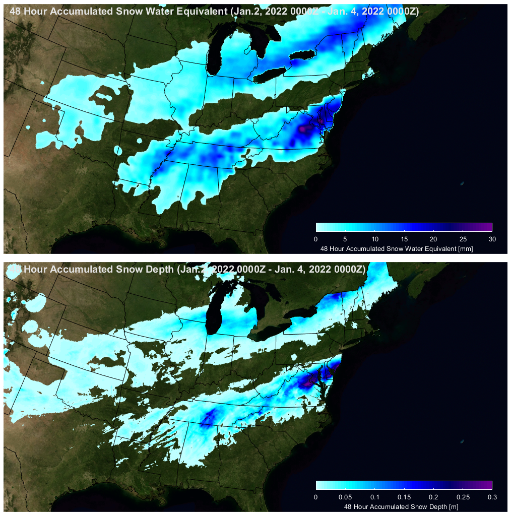
The figures above compares 48-hr snowfall accumulations between SFR and NWS SNODAS snowfall analysis. The patterns of intense snowfall in the two maps agree well with each other. An animation of the snowstorm made from the SFR product can be found at the following link:
Meng is a physical scientist with NOAA/NESDIS Center for Satellite Applications and Research, Satellite Climate Studies Branch, and a Visiting Research Scientist at ESSIC. She received a MS in Physical Oceanography from Florida State University in 1993, and a PhD in Hydrology from Colorado State University in 2004. She has been working in the field of satellite remote sensing since 1999. Her current research focuses on snowfall retrieval using passive microwave measurements from polar-orbiting satellites.
Dong is a faculty specialist at Earth System Science Interdisciplinary Center (ESSIC) and Cooperative Institute for Satellite Earth System Studies (CISESS)-Marylandof, University of Maryland. He received his Ph.D degree in Geophysical Fluid Dynamics from Florida State University in 2012. He has over fifteen years of experience in Methodology, Physical Oceanography and Remote Sensing. At ESSIC/CISESS, his work focuses on microwave satellite snowfall rate (SFR) retrieval algorithm development, implementation and real-time SFR product maintenance.
Fan is an assistant research scientist with the Earth System Science Interdisciplinary Center (ESSIC) and the Cooperative Institute for Satellite Earth System Studies (CISESS)-Maryland, University of Maryland (UMD), College Park. He received his B.E. in Electronic Science from Xi’an University of Science and Technology, China and his M.E. in Electrical Engineering and Ph.D. in Physics from Stevens Institute of Technology. His research interests include radiative transfer theory, machine learning, satellite remote sensing of ocean color, aerosols and snowfall.
To access the new Snowfall Rate Page, click here.


