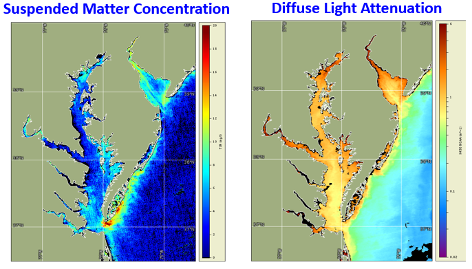
Suspended matter concentration and light attenuation are two satellite water quality products that could be used in combination with other types of data for monitoring water quality improvements and in assessments to determine attainment of water quality standards in Chesapeake Bay. EPA is leading the Chesapeake Bay Program partnership to restore the health of Chesapeake Bay.
Ron Vogel, ESSIC/CISESS Senior Faculty Specialist, served as a subject matter expert at a scientific advisory panel of the Chesapeake Bay Program (CBP), the EPA-led partnership to restore a healthy Chesapeake Bay. The panel sought to advance the CBP’s current water quality data monitoring program to include new technologies such as satellites to improve its water quality assessments. Vogel outlined the current state of the science of satellite data products available for water quality analysis, including surface water light attenuation and suspended matter concentration.
These products help to understand how human sediment contribution from rain run-off impacts the clarity of the water, the health of underwater grasses, and communities’ willingness to undertake recreational activities. Satellite data, with more detailed spatial coverage and higher frequency than ship-based measurements, has potential to fill gaps where current monitoring lacks spatial and temporal specificity. The panel made recommendations to improve the current satellite products. With improved satellite data, water quality assessments, incorporating a combination of data types, can determine whether water quality standards have been achieved, thereby creating a more meaningful diagnostic for measuring the health of Chesapeake Bay.
In his research, Vogel applies earth-observation satellite data to environmental decision-making. He currently develops decision-support tools for water quality, fisheries and climate change in coastal areas. Other interests include ecological modeling with satellite data and vegetation and land surface monitoring by satellite. He has expertise in both visible and infrared satellite remote sensing.

")


