NOAA’s MiRs Captures Category 5 Rainfall Event in California
Cazzy Medley
Highlights
On October 24, a powerful Category 5 (the maximum possible) atmospheric river (AR) occurred over the northern and central parts of California. The storm system featured record breaking precipitation, leading to flooding and mudslides in some locations, along with dangerous winds exceeding 70 miles per hour at higher elevations. San Francisco recorded its fourth highest single-day rainfall amount of over 4 inches. Satellite passive microwave measurements are one of the observational tools that allow depiction of these extreme events, since microwaves are less affected by clouds and precipitation.
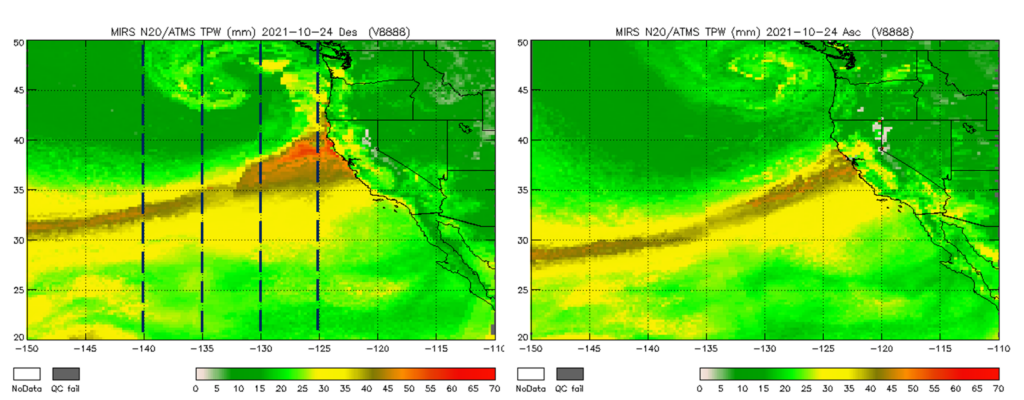
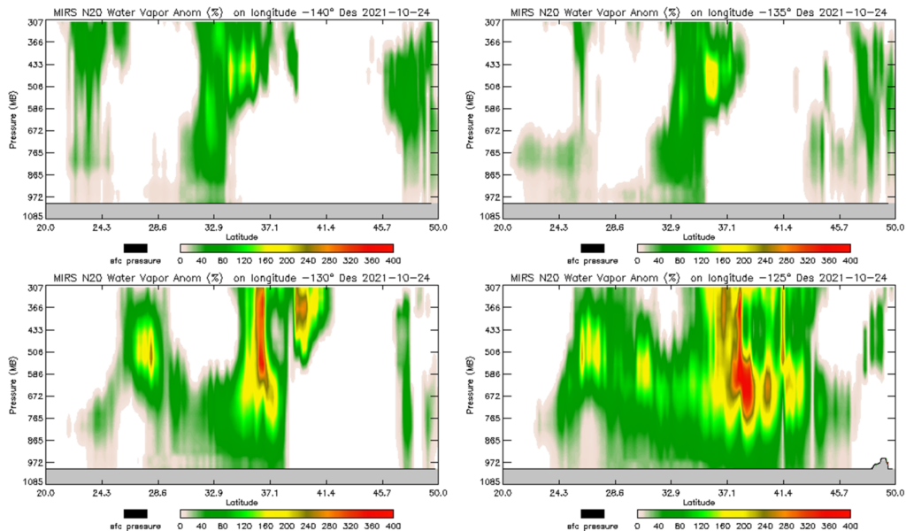
NOAA’s Microwave Integrated Retrieval System (MiRS) water vapor retrievals from NOAA-20/ATMS on this day were used to visualize the structure of the AR off of the California coast. Figure 1 shows the total precipitable water (TPW) retrieved over the region, indicating that the plume of very high TPW (greater than 40 mm) extends well west of the coast and even beyond 150 W longitude. Figure 2 shows four vertical cross-sections of the retrieved water vapor anomaly, along different longitudes in the eastern Pacific. The anomaly is calculated with respect to the mean retrieved conditions at each location for the preceding 10 days (14-23 October).
Several features are notable. First, the structure of the AR is clearly seen in all the cross-sections as an elevated core of large positive anomalies, with the magnitude of the anomalies increasing closer to the coast. Second, close to the coast, at 125 W longitude the retrieved water vapor anomalies are very large, exceeding 400 % in a broad set of layers above 800 hPa. Third, the vertical distribution of the maximum anomaly varies with longitude. For example, further west at 140 and 135 W, the maximum anomaly appears to be focused above 500 hPa, while closer to the coast at 130 and 125 W, the anomaly extends further toward the surface seeming to focus in the 600-800 hPa layer. MiRS retrievals are a significant input to the operational blended TPW and blended layer water vapor products, and the accurate depiction of AR events can help operational forecasters increase situational awareness and potentially improve forecasts and warnings to the public.
Figure 1. MiRS NOAA-20/ATMS retrieved TPW (descending and ascending orbits) on 24 October 2021 over the eastern Pacific and West Coast region. The atmospheric river is clearly seen. Locations of the four vertical cross-sections shown in Figure 2 are indicated by the dashed lines.
Figure 2. Vertical cross-sections of MiRS NOAA-20/ATMS retrieved water vapor anomalies along four longitudes (140 W, 135 W, 130 W, and 125 W) over the eastern Pacific between 20 N and 50 N latitude. Data are for descending orbits on 24 October 2021. The structure of the atmospheric river is depicted, with anomalies exceeding 400 % just off the California coast.
ESSIC Scientist Chris Grassotti is the task lead for the MiRS project and is responsible for leading and coordinating the efforts of the other MiRS team members. Grassotti received a B.S. degree in earth and space science from the State University of New York at Stony Brook, Stony Brook, NY, USA, in 1982, tan M.S. degree in meteorology from the University of Wisconsin-Madison, Madison, WI, USA, in 1986, and an M.S. degree in viticulture and enology from AgroMontpellier, Montpellier, France, in 2007. From 1986 to 1991 and again from 1993 to 2005, he was a Research Associate, Senior Research Associate and Staff Scientist with Atmospheric and Environmental Research, Inc., Lexington, MA, USA. From 1991 to 1993, he was with the Atmospheric Environmental Service, Environment Canada, Dorval, QC, Canada. Since 2008, he has been with the National Oceanic and Atmospheric Administration, NOAA Center for Satellite Applications and Research, National Environmental Satellite, Data, and Information Service, College Park, MD, USA. He has been a Senior Faculty Specialist with ESSIC/CISESS since 2015.
")


