")
ESSIC/CISESS Scientist Korak Saha and collaborator Huai-min Zhang have been improving the NOAA/NCEI Blended Seawinds (NBS) product. NBS blends several satellite estimates of surface wind, providing more accurate and gap-free observational data for model calibration and quality control. NOAA has been producing a global gridded 0.25-degree and 6-hourly sea surface winds product that has wide applications in marine transportation, marine ecosystem and fisheries, offshore winds, weather and ocean forecasts, among others.
The new version of NBS v2.0 contains a long-term sea surface wind product from 1987 to present that can easily delineate high storm winds starting 2012 and with a one-day latency. An examination for multiple cases of tropical cyclones and Hurricanes (see examples in figures below) has been carried out.
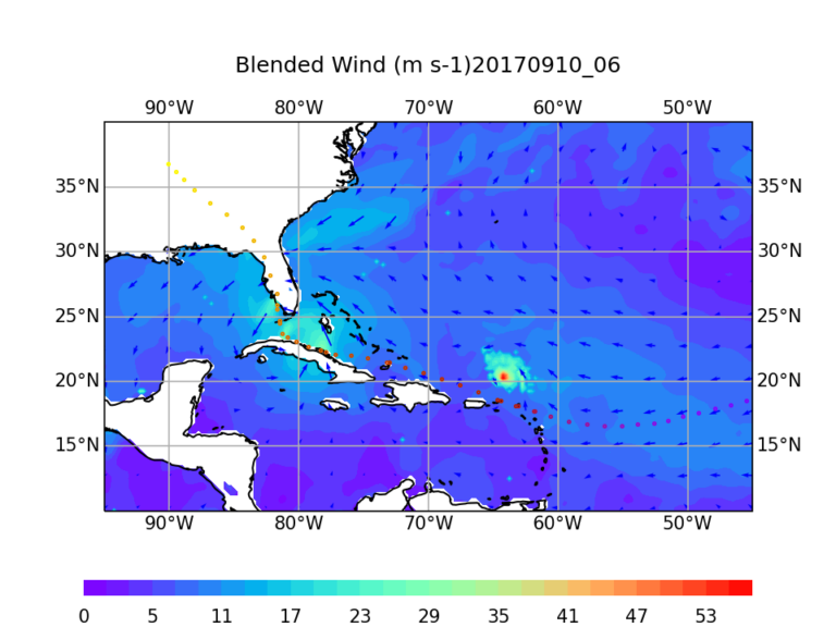
Figure 1: Image showing Hurricane Irma (near landfall in SW Florida), which was followed by Hurricane Jose, of the Gulf of Mexico in 2017. The track for Hurricane Irma only is shown here.
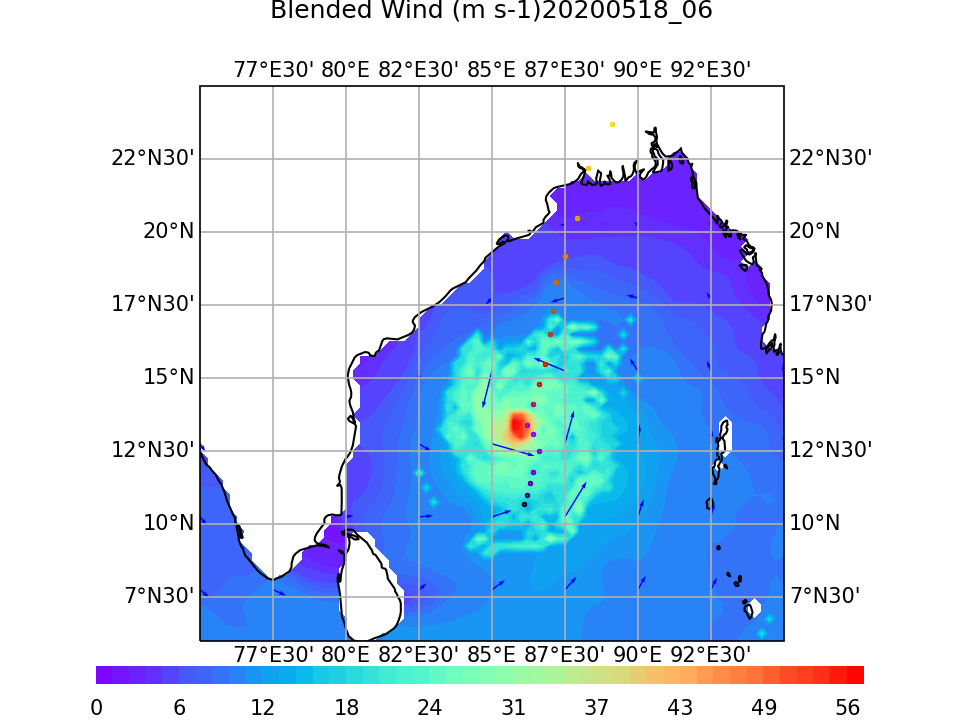
Figures 2 and 3: High winds associated with Super Cyclone Amphan are resolved very well in the NBS v2.0 in comparison to the other blended and reanalysis products.
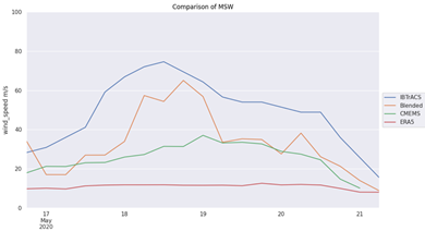
Comparisons with the IBTrACS data shows that NBS v2.0 performs better than the other existing globally gridded gap-free blended and reanalysis products. The NBS product is generated by blending observations from multiple sources (satellites), including scatterometers and microwave radiometers/imagers. However, these sensors do not provide accurate observations of extreme hurricane winds as their signals saturate (level off) in very high winds or degrade in the presence of rain. Recent advancement in satellite wind retrievals revealed that a new L-band (1.42 GHz) instrument on Soil Moisture Active Passive (SMAP) satellite, which started in 2012, can provide accurate hurricane winds up to 65 m/s (145 MPH) without being affected by rain. Similarly, the AMSR2 All-Weather channel (~6.9 GHz), provides rich information about wind speeds in and around storms. Inclusion of both SMAP and AMSR2 inputs using a random error based weighting function dramatically improve NBS v2.0 providing a long-term ocean surface wind product that can easily delineate high winds especially in and around hurricanes and other extreme oceanic storms.
Dr. Korak Saha is working with the NOAA/NESDIS/NCEI, as a ESSIC Assistant Research Scientist and his work involves archival, preserve, disseminate and ensure longtime utility of surface oceanographic dataset. He is involved with SST Climate data record generation and its archival. He is also contributing to NOAA NCEI’s effort to use cloud based technology for geophysical data analysis and using AI/ML techniques for satellite data quality assessment. He is currently leading NCEI’s long-term Blended Seawinds project.


