")
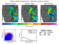
The record-breaking rain and flooding that barraged Maryland and the Mid-Atlantic this past week (July 21-25) was observed twice daily by the Advanced Microwave Scanning Radiometer 2 (AMSR2) onboard the GCOM-W1 satellite. ESSIC / CICS-MD scientist Patrick Meyers (supporting STAR/CoRP*) compared the rainfall estimates from the current operational AMSR2 precipitation algorithm (GPROF2010V2) and its potential replacement (GPROF2017) to radar rain rate estimates.
Comparative analyses show that GPROF2017 both consistently predicts rainfall more accurately than its predecessor does and improves rain rate estimates for tropical air masses over land. In the coming months, GPROF2017 testing will continue, with hopes of making a final determination on its establishment as the replacement for the operational AMSR2 precipitation product.
Meyers is an ESSIC / CICS-MD senior faculty specialist that works primarily with improving satellite rainfall retrievals for the Global Precipitation Measurement Mission (GPM). At ESSIC, he evaluates and develops algorithms for passive microwave retrievals of geophysical parameters, particularly precipitation rates over land.
*The Center for Satellite Applications and Research (STAR) is the science arm of the National Environmental Satellite, Data, and Information Service (NESDIS), which manages the nation’s environmental satellites for the National Oceanic and Atmospheric Administration (NOAA). The Cooperative Research Program (CoRP) is a STAR-supported initiative that manages a coast-to-coast research coalition of the federal government and universities.


