")
Last month, an article titled “Mapping of Snow Depth by Blending Satellite and In-Situ Data Using Two-Dimensional Optimal Interpolation—Application to AMSR2” was published in the journal Remote Sensing by co-authors Cezar Kongoli, ESSIC/CISESS associate research scientist, Tom Smith, ESSIC/CISESS visiting research scientist, and Jeff Key, chief of NOAA’s Advanced Satellite Products Branch.
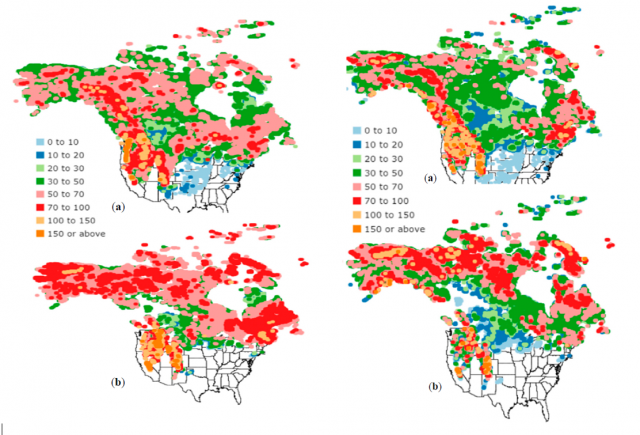
The authors applied a technique called 2-dimensional optimal interpolation to blend AMSR2 and in-situ snow depth in order to improve the retrieval of AMSR2-based snow depth. Testing of the technique over North America indicated an enhanced accuracy of the blended satellite product, especially in mountainous regions. The blended satellite product was also superior to snow depth from NOAA’s Global Forecast System (GFS), indicating a potential for data assimilation improvements using this technique.
Kongoli’s research focuses on satellite hydrometeorology, cold regions hydrology and data assimilation. He is also an affiliate scientist at NOAA/NESDIS and an adjunct professorial lecturer at American University.
Smith is a physical scientist working in analyses that include both satellite and in situ data, and has been with NOAA for nearly 30 years. He has contributed to climate analyses of surface temperature and precipitation used for evaluating historical climate variations.
To read the paper, click here: “Mapping of Snow Depth by Blending Satellite and In-Situ Data Using Two-Dimensional Optimal Interpolation—Application to AMSR2”.


