")
ESSIC/CISESS Scientists Yalei You, John Xun Yang, and Jun Dong have a new article on using “morphing” to improve rain data from cross-track scanning radiometers. The paper, titled “Improving Cross-track Scanning Radiometers’ Precipitation Retrieval over Ocean by Morphing”, is in press at the Journal of Hydrometeorology.
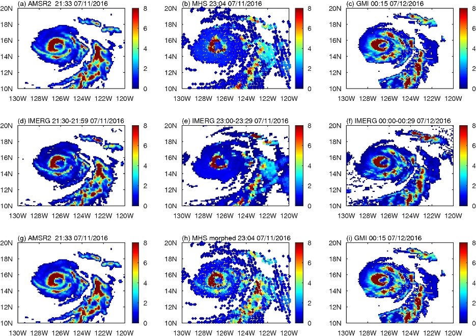
Previous studies showed that conical scanning radiometers greatly outperform cross-track scanning radiometers for precipitation retrieval over oceans. This study demonstrates a novel approach to improve precipitation rates at the cross-track scanning radiometers’ observation time by propagating the conical scanning radiometers’ retrievals to the cross-track scanning radiometers’ observation time, a process called “morphing.” The improved precipitation rate is a weighted average of original cross-track radiometers’ retrievals and retrievals propagated from a conical scanning radiometer. The cross-track scanning radiometers used in the study included the Advanced Technology Microwave Sounder (ATMS) onboard the NPP satellite and four Microwave Humidity Sounders (MHSs) and the conical scanning radiometers included the Advanced Microwave Scanning Radiometer 2 (AMSR2).
Results showed that the morphed precipitation rates agree much better with the reference (Global Precipitation Measurement Microwave Imager). The degree of improvement depends on several factors, including the propagated precipitation source, the time interval between the cross-track scanning radiometer and the conical scanning radiometer, the precipitation type (convective vs. stratiform), the precipitation events’ size, and the geolocation. The study has potential to greatly improve high-impact weather systems monitoring (e.g., hurricanes) and multi-satellite precipitation products. It may also enhance the usefulness of future satellite missions with cross-track scanning radiometers onboard.
You received his B.S. and M.S. degrees in atmospheric science from Yunnan University, Kunming, Yunnan, China, in 2005 and 2008, respectively, and the Ph.D. degree in meteorology from Florida State University, Tallahassee, FL, USA, in 2013. He is currently an Associate Research Scientist with the Earth System Science Interdisciplinary Center (ESSIC) and the Cooperative Institute for Satellite Earth System Studies (CISESS)-Maryland, University of Maryland (UMD), College Park, MD, USA. His research interests include passive microwave precipitation algorithm development, precipitation data set validation, and microwave instrument calibration. You has served as an Associate Editor for the Journal of Hydrometeorology and the Journal of Applied Meteorology and Climatology.
Yang is an assistant research scientist at Earth System Science Interdisciplinary Center (ESSIC) of the University of Maryland. He has over ten years of experience in Earth remote sensing, microwave radiometry, hardware development, calibration, and retrievals. He has been involved with four NASA/NOAA satellite missions, including the Aquarius, GPM, CYGNSS, and JPSS missions.
Dong is a faculty specialist at Earth System Science Interdisciplinary Center (ESSIC) and Cooperative Institute for Satellite Earth System Studies (CISESS)-Marylandof, University of Maryland. He received his Ph.D degree in Geophysical Fluid Dynamics from Florida State University in 2012. He has over fifteen years of experience in Methodology, Physical Oceanography and Remote Sensing. At ESSIC/CISESS, his work focuses on microwave satellite snowfall rate (SFR) retrieval algorithm development, implementation and real-time SFR product maintenance.
To access the article, click here: “Improving Cross-track Scanning Radiometers’ Precipitation Retrieval over Ocean by Morphing”.


