")
By Teri West and Chrysandra Medley
On June 2, a severe storm threatened Rock the South, an outdoor music festival in Cullman, Alabama. In an effort to avoid delaying or canceling the event, forecasters used technology enabled by the Geostationary Lightning Mapper (GLM), a satellite-based lightning mapping instrument designed to aid storm predictions. With the lightning imagery, they could tell that the storm would skirt the festival and the music proceeded as planned.
The GLM, a device aboard the GOES-16 satellite, maps lightning strikes across the Western Hemisphere. It detects lightning optically, as opposed to ground-based networks that detect radio waves. These two sets of data used in conjunction allow for complete coverage over the Western hemisphere.
CICS-MD, which processes data from the GLM, is currently rolling out a flash extent density product to all National Weather Service forecast offices.
The product collects data on the number of lightning flashes that travel through an area over a given time period.
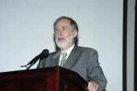
With this data, forecasters can better predict severe weather conditions, allowing decisions makers in turn to improve their safety decisions. Scott Rudlosky, the leader of the development of gridded GLM products at CICS-MD, appeared on The Weather Channel on July 16 for two interviews about the GLM and its flash extent density product
Rudlosky is a SCSB/STAR/NESDIS/NOAA visiting associate research scientist working in collaboration with ESSIC/CICS-MD. He also serves on the National Weather Service (NWS) Lightning Safety Awareness Team and the NWS Total Lightning Implementation Working Group.
“It’s up in geostationary orbit so it constantly stares at the United States and the surrounding oceans and takes 500 frames per second. By doing that, it’s able to capture where the lightning is occurring and also how much lightning is occurring,” said Rudlosky during the interview.
Forecasters have not previously had access to lightning data from space.
“We’ve taken the base GLM observations and really tailored them for the weather service environment. Starting today, forecasters will be able to watch this lightning data and they can look for trends and storms. Once they see the lightning rate ramping up, they can have confidence that that storm is getting more intense and produce severe weather,” said Rudlosky.
Two NOAA Hollings Scholars, William Maguire and Allie Mazurek, are interning with Rudlosky as part of the CICS-MD Summer Institute and are supporting the ongoing research and programming behind the project.
Maguire is a rising senior at Penn State where he studies meteorology. He has been digging through data to understand the fraction of light that the GLM detects.
Mazurek, who studies atmospheric science and geography at the University of Georgia, specifically targeted CICS-MD this summer, given the newness” and innovation of the GLM project.
“It’s been exciting to watch and be a part of – a little tiny part of – something that’s been years and years in the making,” Mazurek said.
She has been reviewing forecaster feedback on the products and coding a program to track GLM outputs. Forecasters will then be able to review past outputs and the GLM team will be able to identify any gaps.
A major addition to GLM tracking will be data from GOES-17, NOAA and NASA’s latest geostationary satellite launched in March of this year. When the satellite eventually reaches its planned GOES-West position, GLM coverage will span from the coast of New Zealand to the western coast of Africa.
To learn more about the GLM and to stay abreast of the team’s research and development efforts, visit Lightning Resources at CICS-MD. To keep up with what is happening at ESSIC, be sure to follow our Twitter (@essicumd) and Facebook accounts.


