")
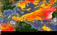
ESSIC / CICS-MD scientist Michael Folmer was the author of a recent post to the Satellite Liaisons Blog that detailed the uncharacteristically far-reaching transport of African dust that reached the central United States. This information was seen by GOES-16, the first of a series of Geostationary Operational Environmental Satellites operated by NASA and NOAA. Folmer writes that the dust was pulled up the East Coast by Hurricane Beryl and Hurricane Chris. These findings are from an ongoing project to test soil moisture and dust products to determine the best tools to monitor the Saharan Air Layer (SAL).
Michael Folmer is an ESSIC / CICS-MD faculty specialist. Currently, he is Satellite Liaison for the Geostationary Operational Environmental Satellite – R-series (GOES-R) and Joint Polar Satellite System (JPSS) Proving Ground at the National Weather Service Ocean Prediction Center, Weather Prediction Center, National Hurricane Center Tropical Analysis and Forecast Branch, and the National Environmental Satellite Data and Information Service’s Satellite Analysis Branch. He focuses on training forecasters at these centers on new satellite products and techniques.
To read Folmer’s full report and see full animations of the dust movement, see: It’s Dusty Out There (in the Atlantic)!


