")
A new NASA Goddard feature highlights how the Ice, Cloud, and Land Elevation Satellite 2 (ICESat-2), originally intended to precisely measure the height of the ice sheets at Earth’s poles, of sea ice floes above the ocean waters, and of forest canopies, has gone beyond its original purposes to map the Earth’s surface. In the article, ESSIC/CISESS scientists Sinéad Farrell and Nathan Thomas are quoted discussing these unintended benefits.
During the summer, networks of rivers and ponds appear on some ice shelves and glaciers. Researchers are also using ICESat-2 to investigate the meltwater that pools on the floes of Arctic sea ice, which can be bigger than Olympic-sized swimming pools and about 2.5 feet deep. Farrell comments that the size of these melt ponds have been traditionally estimated based on relationships between area and depth from fieldwork done in 1998.
“A lot has changed in the Arctic since then – we’ve lost a lot of the thicker, older ice, and so we want to see if those observations made in the ‘90s are still representative today,” Farrell said in the article. With the precise measurements of ICESat-2, scientists can research that question and others.
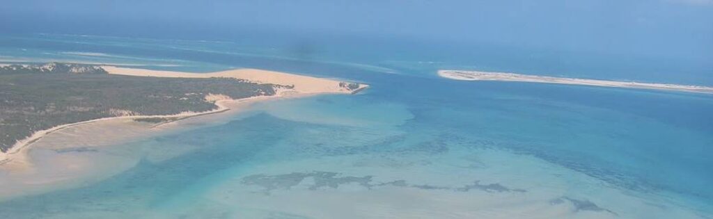
Another unexpected use of ICESat-2 is measuring both the surface of water and the seafloor below it, giving scientists the ability to monitor coastal ecosystems. In the article, Thomas discusses the gap in knowledge about the shallow waters between the coastline and the open ocean. Measuring these areas by ship can be cost-prohibitive and dangerous, so Thomas is working to combine ICESat-2 measurements with existing satellite datasets to map coral reefs, sea grasses, tidal flats, and other aquatic ecosystems.
Thomas is also using ICESat-2 to measure mangrove forests from the tops of the trees to the base of their often-underwater roots. If he and his colleagues can measure the full height of these trees, while compensating for the tides, they can calculate the stores of biomass and carbon held in these forests, and add those to the global ICESat-2 biomass inventory.
Farrell is a principal investigator on the NASA ICESat-2 Science Team and a member of the Mission Advisory Group for the Copernicus Polar Ice and Snow Topography Altimeter. She is also an associate professor with the University of Maryland Department of Geographical Sciences.
Thomas is an ESSIC postdoctoral associate at NASA GSFC. His research focuses on the use of remote sensing technologies to understand the coastal zone and its processes, from sub-aquatic ecosystems up to mangrove forest height and biomass.
To read the NASA Goddard feature, click here: “Beyond Ice: NASA’s ICESat-2 Shows Hidden Talents”.


