")
NOAA Center for Satellite Applications and Research (STAR) scientists are exploring new capabilities of enhancing satellite images with artificial intelligence (AI) so that moderate resolution images could be enhanced to include more detailed features with high resolution.
The Visible Infrared Imaging Suite (VIIRS) science team, which includes ESSIC/CISESS scientists Xi Shao, Bin Zhang, and Yan Bai, has experimented with a couple of AI models for selected sample images with good success during the NOAA GPU Hackathon event. Figure 1 below shows sample output from a European model applied to a Sentinel 2 image with 60-meter resolution (left) to produce a 10-meter resolution image (right) for the San Jose International Airport.
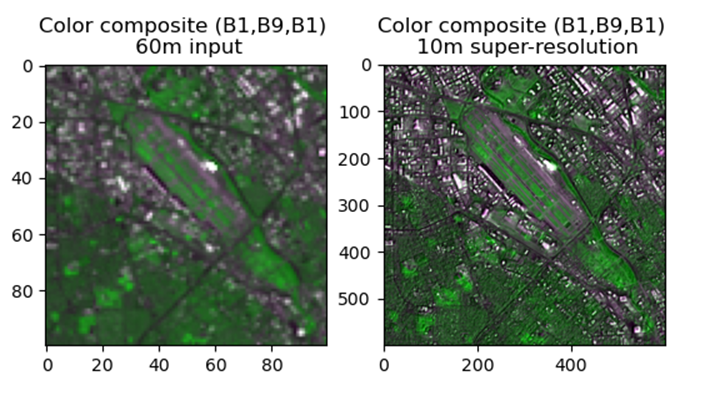
Clearly a great deal of details are added in this process with AI. While it is understood that the super resolution images have limitations such as radiometric fidelity, this technology could be useful for applications such as object identification and graphic display where the radiometric fidelity would not be as critical. The team is working to implement the model to apply to VIIRS images for enhanced resolution to promote the use of NOAA VIIRS data for a variety of applications by users worldwide.
Xi Shao is an associate research scientist at ESSIC/CISESS and Department of Astronomy of University of Maryland. He supports radiometric calibration and validation work for Suomi-NPP and NOAA-20 Visible Infrared Imaging Radiometer Suite (VIIRS) instrument and METimage on EPS-SG.
Bin Zhang is an ESSIC/CISESS assistant research scientist. His research interests include ocean circulation dynamics and ocean state forecasting, satellite sensor calibration/validation.
Yan Bai is senior faculty specialist at UMD/ESSIC/CISESS who supports the VIIRS team in data quality assurance, and web based cal/val systems for imaging radiometers. Her area of expertise is in the VIIRS image processing, analysis, and visualization using a variety of software tools.


