")
Two years ago, ESSIC research associate professor Maria Tzortziou spent two weeks on a ship in the Chesapeake Bay, conducting research as part of a NASA scientific field campaign that would set the foundation for a future NASA satellite mission to study coastal ecosystem processes from geostationary satellites.
This September, Tzortziou, along with 14 other scientists from NASA, NOAA and a number of U.S. universities, traveled to the Gulf of Mexico to conduct a similar mission on a larger scale. The “GoMex” campaign, which ran from Sept. 9-22, brought together experts from a wide range of disciplines, including both experimentalists and modelers, to conduct oceanographic and air quality research in the region.
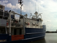
From the turbid coastal waters off the Louisiana shore, where team members gathered samples in an alligator-filled environment, to the clearer blue waters where sharks and dolphins swam alongside the scientists’ ship, researchers on ‘R/V Pelican’ tracked drogues and collected samples for two weeks.
Tzortziou’s role in September’s campaign was multifaceted — in her focus on atmospheric air quality research, she led activities tracking the distribution of air pollution in coastal environments, using a new robot-like spectrometer her team developed to collect measurements of trace gases, such as ozone and nitrogen dioxide, from a constantly moving oceanographic research vessel. Along with NASA oceanographer Antonio Mannino, she also co-led activities tracking dissolved organic carbon in ocean waters to determine the extent of the impact of human activities on its concentration in the water, collecting this data from both offshore and coastal waters, including tidal marshes, clear waters and coastal polluted areas.
“Dissolved organic compounds in coastal waters are sensitive indicators of environmental pollution, nutrient enrichment and water quality, and play a key role in a broad range of processes and climate-related biogeochemical cycles in coastal ecosystems,” she said.
To determine levels of organic carbon, Tzortziou used filters with pore-sized diameters of just 0.22 micrometers to collect “dissolved” organic material in the ocean. Some parts of the scientists’ research was affected by the weather during the campaign, which occurred during hurricane season in the Gulf.
“On some days, we had some rough seas, high waves which made it challenging using our instruments, filtering in the lab, and deploying sensors in the ocean; we definitely got wet!” Tzortziou said.
The entire campaign involved measurements of coastal air-quality and ocean biogeochemical processes taken from the research vessel, as well as an extensive network of ground-based instruments. In addition, two aircrafts flew over the ship to perform remote sensing retrievals and measure atmospheric composition.
The scientists spent 15 continuous days on the ship, Tzortziou said. The first two days were the most challenging, as they adjusted to the challenges of conducting research on the sea.
“It was quite busy on the boat, as people were involved in many different activities, collaborating with one another and helping out with deployment of instruments and measurements in the lab. We had some long days, as some of the operations were extending during the night. The Pelican’s two captains and four additional crew members were extremely helpful with all operations. Having an awesome cook on the ship proved to be truly priceless!” she said.
GoMex was conducted in conjunction with DISCOVER-AQ Texas, a NASA campaign based in the Galveston Bay region that used remote satellite observations to monitor the effects of air quality on human health in the Houston area.
By working with DISCOVER-AQ, GoMex team members were able to obtain measurements from air, sea and land, giving the campaign a truly comprehensive collection of data, Tzortziou said. For example, in addition to taking measurements from the main research vessel, Tzortziou’s team used smaller boats to get closer to marshes and tidal wetlands as well as anthropogenic sources of carbon, nutrients and pollutants, and take coastal measurements that were not accessible from the larger ship. In addition, Tzortziou led coordination of the aircraft flights over the GoMex ship with the DISCOVER-AQ aircraft crew.
The GoMex campaign was organized as part of a preparatory effort for NASA’s GEO-CAPE — short for GEOstationary for Coastal and Air Pollution Events — mission, which will measure tropospheric trace gases and aerosols and coastal ocean phytoplankton, water quality and biochemistry using high-resolution satellite measurements from a geostationary platform. This will allow scientists to identify human and natural sources of aerosols and ozone precursors, track air pollution transport, and understand highly dynamic physical, biological and biochemical processes in coastal ecosystems, Tzortziou said.
The goal of the GoMex campaign was to better understand the time and space scales of biogeochemical exchanges and biological processes in coastal environments, and to determine whether the current measurement requirements and instrument characteristics proposed for the GEO-CAPE Ocean Color sensor are the best choice to address the mission’s scientific objectives while minimizing the complexity, size and cost of the satellite sensor.
“Preliminary analyses look very promising, and we’re happy … since all these measurements [taken throughout the campaign] were coordinated very successfully,” Tzortziou said. “All scientists participating in the cruise will be meeting soon, to synthesize observations and apply results to assess how future NASA ocean color sensors on geostationary orbit can contribute to improved remote sensing capabilities of coastal ocean biology and biogeochemistry.”
Click image to enlarge and display caption:{gallery}Tzortziou{/gallery}


