")
Last month, NOAA/AMS/EUMETSAT held their annual Joint Satellite Conference in Boston, Massachusetts. ESSIC/CISESS had a large contingent of scientists at the meeting presenting posters and giving talks, listed below.
ESSIC scientists’ talks included:
- Scott Rudlosky (SCSB/STAR/NESDIS/NOAA) on Geostationary Lightning Mapper Products
- Hu Yang on Lunar Calibration for Space Borne Microwave Radiometers
- Jingjing Peng on Evaluation of JPSS VIIRS Albedo Estimates against MODIS, APP-x, and CLARA-A2 Albedo Products
- Veljko Petkovic on Quantifying Uncertainties of PMW Satellite Precipitation Climate Data Record
- Tianfeng Chai on Smoke Forecasts using HYSPLIT-Based Emission Inverse Modeling System and NOAA GOES Smoke Product
- Sheekela Baker-Yeboah on Cross-Sensor Analysis of Physical and Biological Implications of Eddy Signatures in the Benguela and California Current Regions
ESSIC scientists’ posters, also focused on their CISESS tasks, included:
- Huan Meng (SCSB/STAR/NESDIS/NOAA) on Near Real-Time Snowfall Rate Applications from S-NPP and NOAA-20.
- Chris Grassotti on NOAA’s Microwave Integrated Retrieval System (MiRS): Operational Update, Applications, and Recent Scientific Progress
- Heshun Wang on NOAA Land Surface Emissivity Product Evaluation and Application in LST Retrieval
- Partrick Meyers on Evaluation of NOAA’s Reprocessed AMSR2 Environmental Data Records
- Lin Lin on JPSS Life-Cycle SDR in NOAA/STAR: SNPP SDR Data Reprocessing and Its Science Impacts
- Ryo Yoshida on GLM Product Evaluation Using Ground-Based Lightning Detection Networks
- Yan Bai on Comparing SNPP/NOAA-20 VIIRS DNB Reflected Lunar Radiance over DCC
- Peng Yu on the GOES-R Land Surface Temperature Product Assessment
- Zhipeng Wang on Radiometric Characterization and Calibration of GOES-R ABI IR Bands
Ralph Ferraro also co-authored three posters.
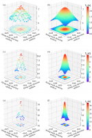
ESSIC/CISESS Scientist Korak Saha (NCEI) had a poster on the Triple Collocation Method (TCM), a technique for estimating the unknown error standard deviations of three mutually independent measurement systems without treating any one system as a perfectly observed “TRUTH.” He compared sea surface temperature data from (1) in-situ ships and buoys; (2) the ENVISAT Advanced Along-Track Scanning Radiometer (AATSR) Reprocessing for Climate (ARC); and (3) the Advanced Very High Resolution Radiometer (AVHRR) Pathfinder SST dataset (see figure below). Using TCM, he calculated RMSE as 0.31 to 0.37 K for the Pathfinder data and as 0.18 to 0.33 K for the ARC data
Additionally, Scott Rudlosky, Jonathan Wynn Smith, and Dan Lindsey spoke on “Using Satellites to Nowcast Convection over South America” as part of the Short Course on Significant Hazards Satellite Applications.


