")
While authorities struggled to combat wildfires that raged in Colorado and New Mexico in June, ESSIC’s Wilfrid Schroeder collected data on the blaze with an eye in the sky.
Schroeder is a member of the team responsible for the Visible Infrared Imager Radiometer Suite (VIIRS) sensor, which provides satellite data on a variety of land and ocean features like land cover, ocean temperature and fires.
Schroeder, an assistant research scientist, said that the U.S. Forest Service (USFS) and the National Weather Service (NWS) both use this data to determine the extent and damage of fires and use this information to coordinate response action.
The data even shows smoke density and location, data that can be used to guide evacuation plans and warnings.
“We give them an outline of fire lines and imagery of the actual fires to help evaluate the situation,” Schroeder said. “It gives them diagnostics of the situation.”
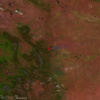
Looking at pictures of the Colorado wildfires (see picture at left), Schroeder said the fires were “gigantic” and the area of effect was “extensive.” He said that although fires like these are unusual to see on a yearly basis, they are not unheard of and usually occur “every five years or so.”
Schroeder said he believes that, while there are some indications – like increasingly dry conditions – that the climate is changing, more time is needed before a firm conclusion can be made about whether severe wildfire events can be attributed to climate change or natural variation of the ecosystem.
Still, he said that wildfires such as these two recent cases “absolutely” represent a national security issue.
The Station Fire of 2009 burned barely off the north side of NASA’s Jet Propulsion Laboratory (JPL) campus in California, threatening the Deep Space Operations Center, which serves as the nerve center for “three major antenna sites, numerous mission operation centers…and more than 30 spacecraft flying throughout our solar system,” according to a 2009 JPL release.
While the destruction of such a facility would not necessarily represent a risk to national security, Schroeder said that a similar situation could happen to power lines, potentially leaving thousands without power, or even to a nuclear power plant.
In order to minimize such risks, Schroeder said that vigilant monitoring of satellite data on active fires, as well as land conditions, is the best way to make wise decisions when allocating resources to control wildfires.
Schroeder said that the USFS has long monitored and regulated fuel build-up – dead trees and dry brush – in the environment and that it is very well aware of the problem.
“There’s little that man can do to stop them or minimize development or spread once they’re going,” he said. “All they can do is use available data and keep their eyes open.”


