ESSIC Researcher Kimberly Slinski is the Principal Investigator on “Earth Observation-Based Monitoring and Forecasting of Rangeland Water Resources”, a newly funded project that aims to develop new capabilities for monitoring and forecasting water availability in African rangeland ponds. The project team includes Shrad Shukla and Chris Funk of the University of California Santa Barbara, Mike Jasinski of NASA GSFC, and Gabriel Senay of USGS.
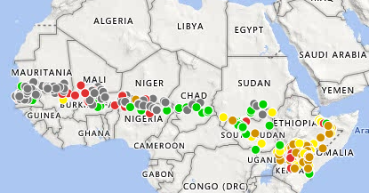
Slinski is partnering with the United States Agency for International Development’s (USAID) Famine Early Warning Systems Network (FEWS NET). FEWS NET is a leading provider of early warning and analysis on acute food insecurity around the world. The organization maintains the Water Point Viewer, an interactive map that monitors the depth and area of 234 water points across central Africa, from Mali to Somalia.
In its existing form, the tool helps stakeholders understand the current availability of water for livestock and human consumption, which in turn informs food security analysis, humanitarian assistance planning, and a range of other activities. However, Slinski’s project will significantly expand and improve the existing Water Point Viewer, increasing the locations monitored, developing new time series of water point surface area using high-resolution satellite data, and improving overall model physics. These developments will lead to the most substantial contribution of this work: new predictive capabilities for forecasting water point stress.
“Enhancing predictive capabilities in this region would be huge,” says Slinski, who specializes in remote-sensing and model-based tools for hydrologic analysis in data-sparse regions.“Many of these communities are largely pastoral, and giving stakeholders predictive capabilities would allow them to adapt to changing climatic conditions much faster than they would otherwise.”
Currently, climate services in East and West Africa have limited capacity to predict water availability. The proposed system will fill this gap, forecasting water point stress at weather, sub-seasonal, and seasonal time scales. The advanced data streams will allow disaster response agencies to better plan for and implement mitigating actions, including ensuring access to alternate water supplies through water trucking or increased maintenance and repair of groundwater pumping stations. Mitigating actions also include limiting herd size to a number that can be supported by rangeland conditions (de-stocking). These actions are costly to implement. Therefore, good data on current and forecasted conditions are essential to the decision makers responsible for implementing drought-response actions.
The proposed work consists of four tasks:
- Task 1: Employ machine learning methods using high-resolution synthetic aperture radar and multispectral data (such as from Landsat, Sentinel 1 & 2, NISAR) to identify rangeland water points and generate an observation-based time series of water point area.
- Task 2: Simulate water availability at each water point with a satellite data-driven water balance model. The model will be forced using satellite- and Earth systems model-based meteorological data, and calibrated using the observation-based time series.
- Task 3: Forecast water availability at each water point using the calibrated model driven by meteorological forecasts at the weather, sub-seasonal, and seasonal scales.
- Task 4: Engage stakeholders at critical points in the project cycle, including needs assessment, verification of new water points, system pilot testing, and during the development of the web interface. This task also includes stakeholder training to ensure their full integration into stakeholder water stress and food security assessment and prediction workflows.
“I am excited and proud to work with my colleagues at FEWS NET, and hope that this work will enable similar work in other food-insecure regions of the world.”
This project is one of the 30 chosen from NASA’s recent solicitation for proposals to support the research, development, and deployment of applications using Earth observations for water resources management. The total combined funding for these investigations is approximately $22 million over 3 years.


