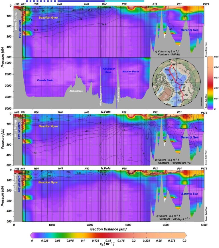
Alexey Mishonov, ESSIC/CISESS Associate Research Scientist and NOAA Affiliate, with colleagues from the Texas A&M University, College Station and University of California, Santa Cruz, has created the first trans-Arctic section of beam attenuation to estimate particle distribution.
In a study published in Journal of Geophysical Research: Oceans, Mishonov and his coworkers combined optical data from two 2015 fall expeditions to the Arctic meeting at the North Pole. The researchers couple high-resolution optical measurements of particle concentration throughout the water column with simultaneous measurements of salinity, temperature, chlorophyll-a fluorescence, and nitrate. They analyzed particle composition from filtered samples, which aided significantly in discerning sources, distribution, and dynamics of particles.
Dense, nutrient-rich Pacific water comes through the Bering Strait and sinks below a thin, low-density, low-nutrient surface mixed layer, forming a thick lens of higher salinity water. Based on low chlorophyll concentrations in nutrient-poor surface mixed layers, surface-water photosynthesis is likely inhibited in some areas, but subsurface chlorophyll-a maxima are observed when nutrients and sufficient light are available. Nutrient-rich Atlantic water enters the Barents Sea, fueling high surface chlorophyll-a concentrations. Surface water cools, forming high-density water that cascades into ∼400 m basins in Barents Sea and into Nansen Basin, eroding sediments that form patches of turbid layers (nepheloid layers) along slopes and in shallow basins. Intense bottom nepheloid layers in the deep basins are rare, suggesting weak bottom currents.
Mishonov is a researcher with extensive experience in various fields of oceanography, including ocean color, water transmissivity and particulate organic carbon study, oceanographic data management, analysis, and climate research.
To access the article, click here: “Distribution, Sources, and Dynamics of Particulate Matter Along Trans-Arctic Sections”.

")


