")
DCLMA plus SRSOR Provides a Glimpse into the GOES-R Era
By: Scott Rudlosky
Imagery created by Patrick Meyers (CICS-MD)
Preparations for the next generation geostationary satellites (GOES-R series) began several years ago. Many new products have been developed and demonstrated to prepare users to take full advantage of the GOES-R observations as soon as the data begins flowing. Two of these demonstration projects provided coincident observations over the Mid-Atlantic region during a severe weather event on 13 June 2013. These experiments provided a glimpse into the GOES-R era, when these capabilities will be routine and freely available to all.
The first project is the Washington D.C. Lightning Mapping Array (DCLMA), which consists of 10 sensors that monitor very high frequency radio waves emitted by lightning. The DCLMA has been operational since 2007, providing detailed 3-D lightning observations that help inform decision makers regarding severe weather and lightning threats. The DCLMA clearly depicts the areal coverage of lightning in real time, and is used as a proxy for the planned GOES-R Geostationary Lightning Mapper (GLM).
The second demonstration shows the added utility of the more frequent 1-min mesoscale refresh rate that will be routinely available from the GOES-R Advanced Baseline Imager (vs. the present 15-min refresh rate). The backup geostationary satellite (GOES-14) temporarily acquired 1-min super rapid scan (SRSO) imagery to showcase the benefits of high-temporal resolution. Note that SRSO operations provide 26 consecutive 1-min samples that are separated by 15-min gaps.
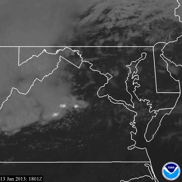
The image below combines visible GOES imagery and DCLMA observations to illustrate an example product that could be provided to weather forecasters and broadcast meteorologists in the GOES-R era. The tracks and locations of two tornados (red lines/circles) also are overlaid to highlight an important relationship between lightning activity and severe storms. Recent studies have shown that rapidly increasing lightning flash rates (termed lightning jumps) often precede severe winds, hail, and tornados. Lightning jumps are evident ~20 minutes prior to the each of the tornados, and frequent lightning flashes persist throughout the tornado durations.
Click the image above if you are patient and would like to view/save a higher resolution animation covering a longer period of time.
Additional Links
Higher-Resolution Loop (minus lightning)
GOES-14 Imager 2013 1-min imagery (SRSOR) Webpage


