")
By Tori Tanner
In late November 2016, a new satellite–that many are calling the most significant step forward in modern weather forecasting history—achieved a geostationary orbit.
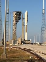
Launched on November 19 from NASA’s Kennedy Space Center in Cape Canaveral, Florida, the Geostationary Operational Environmental Satellite R Series (GOES-R) is destined to revamp NASA’s current line-up of geostationary satellites.
ESSIC Post-Doctoral associate Michael Peterson was at the launch. He described the scene to be one full of “NASA fan-boys” where everyone is waiting with baited breath for the launch to start.
The first in the GOES-R series, also known as GOES 16, will provide many necessary and improved functions including enhanced hurricane tracking, increased thunderstorm and tornado warning lead time, and an earlier warning system for ground lightning strike hazards.
Peterson is most excited about the Geostationary Lightning Mapper (GLM).
“It’s the first of its kind,” he said. “You can now see what’s happening in those clouds, where the strong weather is and where you might expect to see strong weather based on the clouds.”
Operational since 1975, the GOES satellites provide scientists with images of the Earth and atmospheric conditions; GOES 16 follows the earlier GOES 13, 14, and 15 series units that were launched in the late 2000s.
According to the launch press release from NOAA, the new series will enable scientists to learn more about the Earth’s weather patterns and predictability, given that the satellite will be capable of scanning the planet five times faster and with four times the resolution than any other satellite. The GOES 16 will become fully operational within a year after scientists check and validate the six instruments.
The new satellite joins three others currently orbiting the planet and will eventually replace one that is aging. The second satellite in the GOES-R series will launch in 2018, and all together the GOES-R series satellites should be launched through 2036.
Peterson noted the order of magnitude improvement of the GOES-R series as being described as “going from analog to digital TV,” given the increased resolution and decreased time between images. The GOES-R series itself is part of NASA’s $11 billion project to revamp and expand weather forecasting, with an emphasis on protecting life and property.
Researchers at the Cooperative Institute for Climate and Satellites – Maryland (CICS-MD) will be focusing their efforts on precipitation projects.
Patrick Meyers, a CICS/ESSIC faculty specialist, explained each of NOAA’s partners was tasked with overseeing part of the satellite. CICS-MD was given the water cycle.
Meyers explained the advanced resolution and image capturing capabilities of the GOES-R series will provide CICS with the ability to see storms form.
“They’ll be certain areas where you get an updated image every minute,” he said, as opposed to the current 15-minute intervals.
Researchers are working to adapt projects that will benefit from GOES-R data streams without becoming overwhelmed by the data. These projects will help advance models and hopefully improve weather prediction.
CICS is also home to the Proving Ground and Training Center (PGTC), that’s trying to replicate the offices of national weather centers to bring forecasters and researchers together.
“We can demonstrate the products we’re developing, to try to help them forecast,” Meyers explained. “While at the same time they can tell us what they like and don’t like.”
Having forecasters and researchers work together will hopefully improve warning times and weather systems that the GOES-R satellite will be capturing.
“The double edge sword of GOES-R is that suddenly we’re going to have so much more information,” Meyers said.
He explained it could be an information overload for some people on tighter schedules than researchers.


