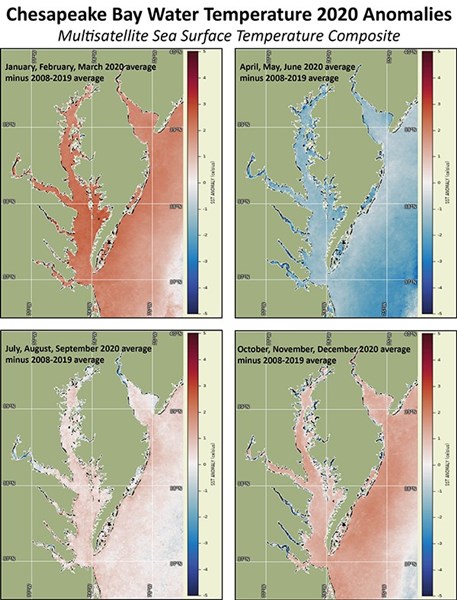
Figure: Satellite SST seasonal anomalies show warmer than average water temperatures from January through March 2020, cooler than average from April through June, near average July through September, and slightly warmer than average October through December.
ESSIC/CISESS Senior Faculty Specialist Ron Vogel, in his role supporting the NOAA CoastWatch East Coast Regional Node, was recently recognized and highly praised for his contributions to the NOAA Chesapeake Bay Office to identify satellite derived products that support habitat and fisheries management applications.
Vogel collaborated with NCBO’s Ecosystem Science Team by providing analysis of Bay water temperature anomalies which were used to identify interannual changes in seasonal water temps that impact blue crabs, oysters, striped bass and other ecologically and commercially important species. He contributed to the Mid Atlantic State of the Ecosystem Report, part of the NOAA IEA program and a report used by the Mid Atlantic Fishery Management Council to implement their ecosystem approaches to fishery management plan. Vogel has also applied novel uses of satellite total suspended matter (TSM; such as sediment) values to evaluate the effects of large, tributary scale oyster restoration. This approach helped to assess the ecosystem services provided by the world’s largest oyster restoration occurring in the Chesapeake Bay and is being submitted as a NOAA tech memo.
In his research, Vogel applies earth-observation satellite data to environmental decision-making. He currently develops decision-support tools for water quality, fisheries and climate change in coastal areas. Other interests include ecological modeling with satellite data and vegetation and land surface monitoring by satellite. He has expertise in both visible and infrared satellite remote sensing.

")


