Home » Highlights » Page 13

Category: Highlights

Figure: Vertical profiles of co-located LEO AMVs and RAY (red) and MIE (blue) winds. The top row shows the Arctic (north of 60° N), (a) mean AMV HLOSV (solid lines), Aeolus HLOSV (long dashed lines; m s−1), and mean AMV wind speed (short dashed lines; m s−1), (b) MCDs (solid), SDCDs (short dashed), and AMV HLOSV error, as represented by SDCD–Aeolus L2B uncertainty (long dashed; m s−1), and (c) co-location counts. Panels (d–f) are as in panels (a–c) but for the Antarctic (south of 60° S). Colored open circles indicate levels where MCDs are statistically significant at the 95 % level (p value < 0.05), using the paired Student’s t test. Vertical zero lines are displayed in the center panels in black. Levels with observation counts > 25 are plotted.

Atmospheric Motion Vector Bias and Uncertainty

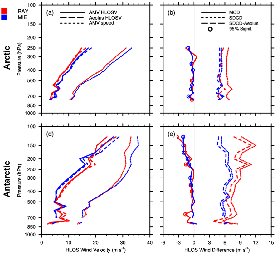
ESSIC/CISESS Scientists Katherine Lukens (a former CISESS grad student), Kayo Ide, Hui Liu, and Ross Hoffman have a new article in the journal Atmospheric Measurement Techniques about their work with the NOAA/NESDIS Office of Projects, Planning, and Acquisition (OPPA) Technology Maturation Program (TMP). The need for highly accurate atmospheric wind observations is a high priority in the science community, particularly for numerical weather prediction (NWP). To address this need, this study leverages Aeolus wind lidar level-2B data provided by the European Space Agency (ESA) as a potential comparison standard to better characterize atmospheric motion vector (AMV) bias and uncertainty.

Read More »
Striping of MetOp-A MHS on July 1, 2019

Quantifying and Characterizing Striping of Microwave Humidity Sounder With Observation and Simulation

ESSIC/CISESS scientists John Xun Yang, Yalei You, and Rachael Kroodsma are co-authors on a new paper in IEEE Transactions on Geoscience and Remote Sensing alongside Sidharth Misra from NASA Jet Propulsion Laboratory and William Blackwell from MIT Lincoln Laboratory. Blackwell is also a two-time speaker for the ESSIC Seminar Series, the most recent of which can be viewed here.

Read More »
Suspended matter concentration and light attenuation are two satellite water quality products that could be used in combination with other types of data for monitoring water quality improvements and in assessments to determine attainment of water quality standards in Chesapeake Bay. EPA is leading the Chesapeake Bay Program partnership to restore the health of Chesapeake Bay.

Ron Vogel Advises Chesapeake Bay Program

Ron Vogel, ESSIC/CISESS Senior Faculty Specialist, served as a subject matter expert at a scientific advisory panel of the Chesapeake Bay Program (CBP), the EPA-led partnership to restore a healthy Chesapeake Bay. The panel sought to advance the CBP’s current water quality data monitoring program to include new technologies such as satellites to improve its water quality assessments. Vogel outlined the current state of the science of satellite data products available for water quality analysis, including surface water light attenuation and suspended matter concentration.

Read More »
A visualization of Living Breakwaters in New York Harbor, one of the case studies in this paper.

Refining Coastline Management with Three Case Studies

ESSIC Visiting Associate Research Professor Ariana Sutton-Grier has a new paper out alongside co-authors from UMD and other international organizations. In the study, titled “Innovations in Coastline Management With Natural and Nature-Based Features (NNBF): Lessons Learned From Three Case Studies”, researchers discuss three case studies on innovative coastal resilience projects in the US that use natural and nature-based features: 1) Living Breakwaters in New York Harbor; 2) the Coastal Texas Protection and Restoration Study; and 3) the South Bay Salt Pond Restoration Project in San Francisco Bay.

Read More »
Santiago Gasso poses in front of a blurred landscape

Gassó Talks Earth Science In Spanish Interviews

On the occasion of Earth Day, ESSIC Scientist Santiago Gassó was interviewed by several international and domestic media outlets for Spanish audiences. The interviews consisted of brief live and recorded video segments meant to highlight NASA’s commitment to Earth science observations since its inception.

Read More »

A New NOAA Blended Soil Moisture Product that Does Not Rely on Model Climatology

ESSIC/CISESS Scientists Jifu Yin, Jicheng Liu and Ralph Ferraro published a new article last month that discussed their work with NOAA’s Soil Moisture Operational Product System (SMOPS). SMOPS is developed by National Oceanic and Atmospheric Administration (NOAA) to provide the real time blended soil moisture (SM) for Numeric Weather Prediction and National Water Model applications.

Read More »
Figures 1 and 2: Snowfall rate from Pacific Northwest snowstorm on April 13, 2022, (left) NOAA-20 SFR, (right) NOHRSC

Microwave Snowfall Rate Product Captures Late Season Pacific Northwest Snowfall

The STAR scientist team of Huan Meng, Yongzhen Fan, Jun Dong, and Yalei You examined the performance of snowfall estimates from the passive microwave snowfall rate (SFR) product for the late season snowstorm that hit Washington and Oregon on April 13. The storm set the local record for most snow accumulation this late in the season, causing power outages and road closures across Portland, Oregon.

Read More »