")
Task 226
Development of the Land Information System (LIS) Framework
Principal Investigator(s):
K. Harrison
Sponsor(s):
C. Peters–Lidard
Last Updated:
May 14, 2013 16:46:17
Description of Problem
NASA’s Land Information System (LIS) is a high performance land surface modeling and data assimilation system. LIS supports global water cycle research, as land surface models predict key inputs to study of the water cycle, including terrestrial water, energy, and biogeophysical states. This project involves adding functionality to LIS through its coupling to other physical models and through the addition of advanced algorithms to maximize the utilization of available data and science. Recent extensions to LIS include a new optimization and uncertainty analysis subsystem and support of radiative transfer model coupling. These extensions allow us to more fully exploit satellite data to advance science and address agency goals. The coupling of a radiative transfer model to LIS moves us more towards direct assimilation of satellite data into land surface models. The optimization and uncertainty modeling algorithms in LIS allow for use of satellite (and other) data for parameter estimation and probabilistic prediction. These new capabilities will improve land surface prediction and therefore global water cycle prediction. New algorithms/coupled models hold potential for improving predictions. They need to be added into LIS and fully tested on real problems to assess resulting improvement and identification of areas that would benefit from further research.
Scientific Objectives and Approach
Our specific objectives are:
• To validate satellite-observed emissivity and radiance simulations from LIS-CRTM, the Joint Center for Satellite Data Assimilation (JCSDA)-developed Community Radiative Transfer Model (CRTM)
• To analyze the sensitivity of LIS-CRTM to internal parameters
• To implement and test optimization and uncertainty algorithms
• To evaluate the improvements in predictive capability over several study sites for which benchmarks are available
Accomplishments
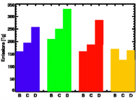
The LIS-CRTM validation begun in 2009-2010 was extended in two ways. LIS-CRTM emissivity estimates were compared against inversion-based estimates of emissivity; previously the validation focused on satellite-observed radiance (brightness temperature). Further, the length of the validation time period was extended from 1 years to 3 years as more data was made available from the Global Precipitation Measurement (GPM) Land Surface Working Group. An error analysis was conducted to identify the conditions leading to LIS-CRTM errors and a calibration exercise is planned. In the LIS software optimization and uncertainty estimation subsystem, new algorithms were implemented to analyze uncertainty prior to and after consideration of remote sensing observations. These new algorithms include an uncertainty propagation scheme (standard Monte Carlo) and a Markov chain Monte Carlo Bayesian algorithm (Differential Evolution Monte Carlo). In Figure 1, the benefit of the uncertainty estimation subsystem is presented in an example showing the reduction in land surface modeling uncertainty made possible with remote sensing data.
Refereed Journal Publications
Kumar, S., R. Reichle, K. Harrison, C.D. Peters-Lidard, S. Yatheendradas, and J.A. Santanello. “Model parameter estimation for a priori bias correction in land data assimilation: A soil moisture case study" [Paper #2010WR010261] to Water Resources Research; accepted pending revisions.


