")
Task 134
Dynamic Downscaling and Urban Land Use
Principal Investigator(s):
R. Murtugudde
Collaborators:
J. Strack
Sponsor(s):
M. Imhoff
Last Updated:
October 26, 2012 15:25:34
Description of Problem
This task provides additional support to look at the use of Terra and other data sets in the application of urban related impacts to the Chesapeake Bay environment within the context of the on-going CBFS. The impact of Urbanization, land use, and heat island effects on weather and climate is being studied in a dynamic downscaling framework for Regional Earth System Prediction. Urban areas are known to alter local temperature and winds due to differences in surface roughness, albedo, and surface sensible and latent heat fluxes. As the human population continues to grow we can also expect urban areas to expand and potentially affect weather and climate on a regional scale in some areas.
Scientific Objectives and Approach
We plan to run high resolution WRF simulations (2-km), using NARR as forcing, over the upcoming year with the goal of determining the extent of the Baltimore-Washington urban heat islands under different synoptic weather conditions. In addition, we will run simulations with the urban areas removed and expanded by arbitrary amounts for comparison with the present day condition. We will use the NOAH land surface model urban scheme along with MODIS land cover data. We had originally hoped to compare Terra/Aqua derived profiles of temperature and water vapor to the model output, however, the data lack sufficient vertical and temporal resolution for this purpose.
Accomplishments
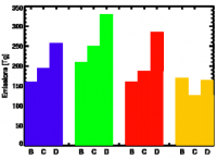
We have just started work on this task in February 2011. One WRF 2-km resolution WRF simulation has been run July 6, 2010 over the Washington DC and Baltimore urban areas using MODIS land cover data. This run was forced with the North American Regional Reanalysis (NARR). The figure at right clearly shows the extent of the heat islands generated by these cities.
Refereed Journal Publications
Anderson, C. R., M. R. P. Sapiano, M. B. K Prasad, W. Long, P. J. Tango, C. W. Brown, and R. Murtugudde, 2009: A Predictive Habitat Suitability Model For Potentially Toxigenic Pseudo-Nitzschia Blooms in The Chesapeake Bay. J. Mar. Sci., in press.
Constantin de Magny, G., W. Long, C. W. Brown, R. R. Hood, A. Huq, R. Murtugudde, and R. R. Colwell, 2010: Predicting the Distribution of Vibrio in the Chesapeake Bay: A Case Study With Vibrio cholerae. Ecohealth, DOI: 10.007/s10393-009-0273-6.
H. Meng, A. Sexton, M. Maddox, A. Sood, C. Brown, R. Ferraro, R. Murtugudde, 2009: Modeling the Chesapeake Bay watershed using SWAT: Rappahanock, the Pilot River Basin. Appl. Eng. Agricult., revised.
Murtugudde, R., 2009: Regional Earth System prediction As a Decision-making Tool for Iran. Environ. Fenn., in press.
Murtugudde, R., 2009: Regional Earth System prediction: A decision-making tool for sustainability? Curr. Op. Environ. Sust., 1, 37-45.
Prasad, M. B. K, M. R. P. Sapiano, C. R. Anderson, W. Long, R. Murtugudde, 2009: Long–term Variability of Nutrients in the Chesapeake Bay: A Retrospective Analysis, 1990–2006. Environ. Coasts., accepted
Other Publications and Conferences
Books and Book Chapters:
Murtugudde, R, 2010: Observational needs for sustainable coastal prediction and management. Murtugudde, in Management and Sustainable Development of Coastal Zone Environ., A. Ramanathan, P. Bhattacharya, T. Dittmar, B. Prasad, and B. Nepunae, Eds., Springer, in press.
Other Publications, Presentations and Awards:
Murtugudde, R., 2010: Observational needs for regional Earth System Prediction, Proceedings of the OceanObs09: Sustained Ocean Observations and Information for Society. J. Hall, J., D. E. Harrison, and D. Stammer, Eds., ESA Publication WPP-306, 2010.
Task Figures
| Fig. 1 – |


