")
Development, Evolution, and Impact of the 2012 Derecho
By: Scott Rudlosky
This article describes the development, evolution, and impact of the 2012 Derecho through the eyes of the many scientists, journalists, and weather forecasters that have since documented its significance. A simple image search for this event yields two common results. The first result is an animation created by NASA that uses visible satellite imagery to illustrate the entire event. The second most common result is a YouTube video that overlays severe thunderstorm warnings with radar imagery following the storm. Although both of these animations are great, I would like to introduce you to an animation created by Ken Pryor (NOAA/NESDIS) that has the best of both worlds. Ken created an animation using composite radar data and GOES-13 water vapor – infrared brightness temperature difference imagery to illustrate the enormous size of the Derecho complex (click here for Ken’s full article).
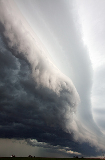
I was (un)fortunate enough to have a front row seat as the storm ever so quietly approached the D.C. Metropolitan region. An eerie combination of lightning flashes and transformer explosions warned of the coming storm, but a lack of thunder increased the suddenness of the gust front’s arrival. My experience was very similar to that of Kevin Ambrose (Washington Post’s Capital Weather Gang), who provides a riveting description of the storm’s approach as it sent him dashing for cover. Fortunately, Kevin also photographed a unique lightning discharge over Washington that night, which we subsequently matched with 3-D lightning data from the Washington D.C. Lightning Mapping Array. Our CWG article showed that the lightning visible in the photo, which seemed limited to downtown D.C., was actually a small portion of a much larger flash that covered over 200 square miles.
Before delving more deeply into the science (i.e., the National Weather Service perspective), I would like to direct your attention to a great article by Bob Henson (UCAR). Bob has long been at the front of his field, creating some of the most enjoyable science writing I have read. Bob’s article begins with the following…”With a ferocity to match the record heat it displaced, a thunderstorm complex raced from Illinois to the Delaware coast in a mere 12 hours on Friday evening, June 29. It knocked down countless trees and power lines, with wind gusts topping 80 miles per hour in many spots. It threw millions of people into turmoil, with air conditioners, computers, and phones out for days. And it brought to light a weather word du jour with an obscure but intriguing history.” If that doesn’t get you excited, we scientists have our work cut out.
The following two sections provide excerpts from the NWS Northern Indiana and Baltimore/Washington forecast offices, which provide detailed discussions of this event. If the science behind the Derecho interests you, I highly recommend following the links to their full discussions.
NWS Northern Indiana – Bently – Click for full article
By early afternoon on Friday, a stationary cold front was draped across the southern Great Lakes. The boundary separated a dry stable airmass to the north and a moist/unstable airmass to the south. The unstable airmass to the south was characterized by temperatures near 100 degrees and dewpoints in the low to middle 70s. This hot/moist surface environment, coupled with mid-level lapse rates between 8.5 and 9 oC/km led to surface based CAPE values of 6000+ J/kg.
Storms initially developed across Northern Illinois during the late morning hours. As these storms continued to grow, the balance between shear and buoyancy created an ideal environment for cold-pool formation and the development of a forward propagating MCS. As this MCS developed into a bowing line of storm and eventually a Derecho, it continued to follow along the instability gradient which is a common occurence in this environment. The storms also continued to form southeast as the system built towards the instability.
The storm continued to intensify as it moved through the Fort Wayne metro area, with widespread winds of 80-90 mph. Outbound velocities measured by the radar were 90 knots around 2500 feet above the surface as the airport reported a 78 knot (91 mph) wind gust. This indicates that the system was very efficient at mixing strong winds aloft down to the surface.
Surface based CAPE (Convective Available Potential Energy) was over 6000 J/kg and the lifted index was -15! Both of these variables indicate that the environment was characterized by extreme instability! The CIN (Convective Inhibition) which had hindered convection earlier in the day is almost completely gone by this point and the environment is primed for intense convection.
0-6 km vertical shear is a parameter commonly used to examine the ability for a storm to sustain itself in an environment and typically a storm needs 30 knots of shear to organize. This sounding shows 36 knots of 0-6 km shear, and this sounding was taken over 100 miles south of our area. The deep layer shear was closer to the 40 to 45 knot range in our area which also aided in the organization of the derecho.
NWS Balitmore/Washington – Zubrick – Click for full article
This summary, using a question-answer format, provides general background on derechos and gives an overview of the derecho that struck the Mid-Atlantic on the evening of Friday, June 29, 2012.
During the afternoon and evening of Friday June 29, 2012, an intense, long-lived line of thunderstorms raced eastward at n
early 60 mph from the Midwest to the Mid-Atlantic coast. In its wake, these storms left behind a swath of destruction that killed at least 20 people, caused millions in property damage, and caused massive power outages in major urban areas along the storm’s path. Meteorologists use the term “derecho” to describe this special type of violent and long-lived windstorm. Because derechos are not common in our region, the term is relatively unknown to residents in the Mid-Atlantic. Typically, our region averages a derecho about once every 2 to 4 years, as shown in the graphic “Derecho Climatology” from the National Weather Service (NWS) Storm Prediction Center (SPC). The last significant derecho to hit the Washington DC-Baltimore metro region was on June 4, 2008.
The following links provide additional information for folks in the Washington D.C. region…
Please let us know if you have any questions or comments regarding the content above or any information provided in the links. Lastly, I would be remiss to avoid mentioning the June 2012 North American derecho Wikipedia page.